
Changing weather patterns may have US citizens unsure about their wardrobe in the coming months.
After record freezing caused citizens of Chicago, IL to rebrand themselves as residents of ‘Chiberia’ over the last few winters, new weather patterns are estimated to provide warmer, drier weather across much of the northern states during this winter season. But that isn’t the only part of the country, or world for that matter, that’s expected to see changes in climate over the next several months. These expectations have been set due to an unusually strong El Niño that’s been developing since summer.
El Niño is the term used to describe a complex series of climactic changes that drive the appearance of unusually warm water in the Pacific region off the coast of Peru and Ecuador. It’s strength is measured by the increase in surface water temperatures against historical averages. In the above chart you can see this area illustrated in red. According to the National Ocean Service the typical effects vary depending on your location in North America.
- Western and Central Canada see warmer-than-average temperatures
- Western and Northern portions of the United States also see warmer-than-average temperatures
- Wetter-than-average conditions tend to occur over portions of the Gulf Coast and Florida
- Drier-than-average conditions are expected to occur in the Ohio Valley and Pacific Northwest
While these are the typical expectations of an El Niño event, there have been cases in the past when more extreme changes have taken place. In 1997, the ENSO (El Niño-Southern Oscillation) cycle drove water temperatures to record breaking levels and brought unusual extremes to much of the US, driving the second warmest and seventh wettest winter since 1895. According to the National Climatic Data Center, it was the cause of an ice storm in the northeast, flooding in California and tornadoes in Florida.
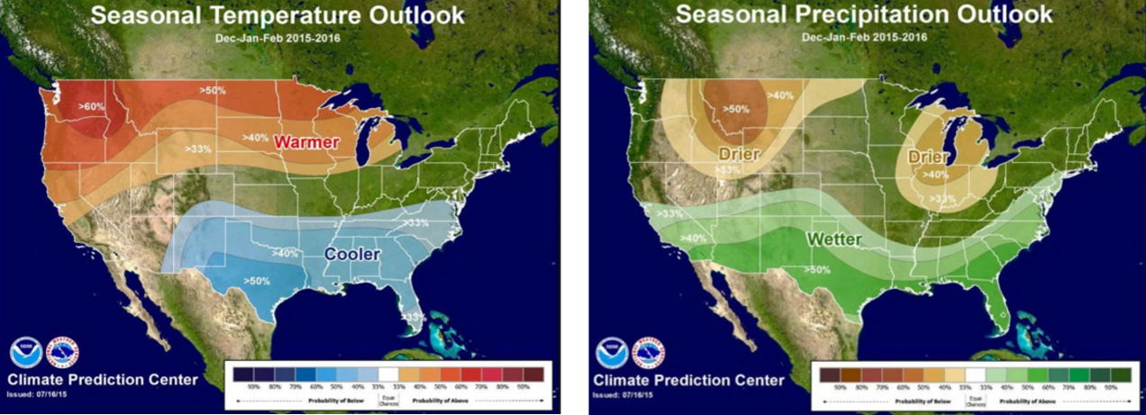
That background is important because the conditions of the current ENSO surpassed those that were recorded in 1997 during the month of September which could predict this to be the most serious in recorded history. Below are a couple of maps that layout estimated effects of this new 2015/2016 El Niño season.
The shifting climate is already starting to be seen in California where massive rainfall has led to violent and dangerous mudslides. According to Ray Pruitt, a spokesman for the Kern County Sheriff Department near Bakersfield, CA, even bulldozers have gotten stuck trying to clear out the 115 cars and 75 tractor-trailers that were stranded.
“It basically looks like a wall of mud,” he said. “I’m looking at semis buried in four feet of mud. It’s a miracle no one was seriously hurt.”
The fact that California got massive amounts of rainfall was strange to begin with, considering they’ve been entrenched in major drought conditions for four years now. Even though this year’s El Niño isn’t expected to fully address the issues of the past four years, it should help. That doesn’t mean it’s arrival should be celebrated though, because prior events suggest the conditions will be dangerous.
In ‘97 the ENSO is estimated to have killed more than 2,000 people worldwide. The city of Los Angeles has already put together a number of recommendations for it’s residents to stay safe, and the Los Angeles Times has expanded on their list. For that part of the country it’s about being protected from floods. For your part of the world it could be entirely different. Take some time to do some research on your area and how you may need to prepare for the shifts in climate. Even if your area isn’t going to be drastically affected by the oscillation, at least you can be properly dressed for whatever it brings your way.
For more information on what El Niño could mean to other parts of the world visit the following: